 This map is a map of the UWF campus. In this lab I created a shapefile, modified an existing shapefile, and also digitized another building and a road. This lab was fairly simple if you paid any attention the the ESRI module. No big issues with this exercise. I also learned a lot from the ESRI readings and exercises.
Saturday, February 27, 2010
Week 7- Data Editing Lab
This map is a map of the UWF campus. In this lab I created a shapefile, modified an existing shapefile, and also digitized another building and a road. This lab was fairly simple if you paid any attention the the ESRI module. No big issues with this exercise. I also learned a lot from the ESRI readings and exercises.
Sunday, February 21, 2010
Georeferencing Lab Map
 This is a map of the UWF Campus. During this lab I used the georeferencing features to combine two different layers, one of which was the correct x,y coordinates and the other layer was a distorted aerial photo. This lab was pretty straight forward and I kind of enjoyed it. I didn't really incounter any issues at all and really thought it was kind of cool to be able to manipulate the map to make a layer match particular points of another layer.
Saturday, February 20, 2010
Data Search Lab Map # 3
 This is a map of the Conservationsal Areas of Broward County,Fl. It includes the areas of invasive plants and all the conservation areas in the county. It took me a little while to find this data, and then when I did download the layers it was a bigger size than my normal county boundry that I had been using the other two maps. So I ended up downloading the county boundry from the same website that I got all the included info that I had so it would all end up being the same size. Also, when downloading the Invasive Plants layer with points it seemed to be really cluttered, so instead of using the points layer I chose to use the group layer and that seemed to releave some clutter and labeled the areas instead of the particular points. Other than that I had no crucial problems. This is my final map which concludes my Data Search Lab.
Data Search Lab # 2 Map
 This is a map of three different raster datasets; DOQQ, DRG, DEM in three seperate quadrants for Broward County,Fl. At first I was kind of at a spot where I wasn't sure what I needed to download and after that how I needed to convert the items to make them work into ArcMap. After some help with some discussion board posts, not knowing what a perfect map in this lab was supposed to look like, I think I pretty much got the right idea about things and it turned out fairly well to my standards. I will have one more final map to complete this lab within the next couple hours.
Thursday, February 18, 2010
Data Search Lab Map #1

This map is projection of Broward County, Fl. It shows the some of the major cities and towns, interstates and major roads. At first, I was really nervous on what to do with this map, and after trying to feel it out and looking at the discussion boards I slowly came to the map that I have completed. It seemed fairly easy after I got the concept down. I had to change the projection layouts on a couple layers, really wasn't really sure if I could make it work but it came out in the wash. I have 2 other maps that I plan on submitting by the end of the weekend, including the other requirements of the lab.
Friday, February 12, 2010
Haiti Participation Post Map
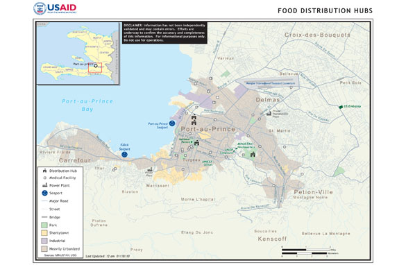 I thought this was an interesting map because it explains the food distribution hubs in Haiti. It also shows medical facilities, power plants, and seaports located in the Port-au-Prince area. I found this map off of a CNN website. The map has pretty much all the nesscessary map elements other than a North arrow. Overall I feel like its a decent map to get the basics on how many support and medical locations are actually in the zone where the quake hit and some other small details about the area.
Monday, February 8, 2010
Week 4- Map Projections Lab
 This map is of three different projections of the state of Florida, and its comparisions of the size of a select number of counties given by each projection. This lab was pretty much clean cut and to the point, and fairly easy to keep up with. I was interested in how much difference there was in the size of the counties given by each of the projections. I also made a simple comparison table by using the Excel program and pasted it to the map document.
Subscribe to:
Comments (Atom)
